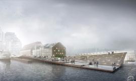
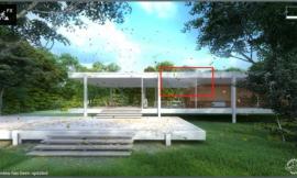
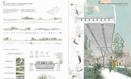
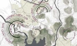
来自专筑编辑刘庆新的报道。我尝试过用波士顿常码头的现存条件为基础来做一个大地分析图。我最感兴趣的就是在图中引入纹理和深度,通常是用单色和非渐变色这种更简单的方式将其表现出来。不要误解,我是BIG类型分析图的忠实粉丝,它实质上是剥去复杂的几何图形,只剩下主要元素来解释一个概念。但是,我想走另一个极端去看看用许多纹理和阴影能生成什么类型的分析图。
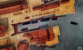
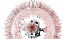
上图是一个将几种不同图层融合在一起的混合图。下图是单个分析图。目的是让每张图看起来都有一点不一样,但是它们都是出自同一个色系。这些图都是在一个Photoshop文件制作出来的,但是有着不同的颜色图层和饱和度。
I have been experimenting with some site diagrams of the existing conditions of Long Wharf in Boston. I am mostly interested in introducing texture and depth to diagrams that are typically presented in a more simplified manner using solid colors and no gradients. Don’t get me wrong, I am a big fan of the “BIG” type diagrams which essentially strip down the graphics to the bare essentials to explain a concept. However, I want to go to the other extreme and see what kind of diagrams can be generated using lots of texture and shading.
Above is a composite image of several different diagrams layered together. Below are the individual diagrams. The goal was to give a slightly different graphical look to each diagram but have the whole series feel as if it came from the same family. These were all generated from one Photoshop file, but with different color overlays and levels of saturation applied to each.
图分步讲解
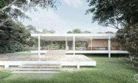
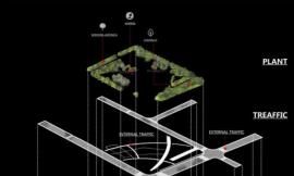
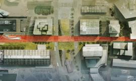
上面几张图是建立在一个简单的基础之上,是由两张图组成的:素模渲染和一张俯视图。我喜欢在俯视图中引进更多的信息、细节和纹理。但是,我降低了一点透明度,这样俯视图就不会太抢眼。在这种情况下,我降低俯视图饱和度,稍后会引进来一些颜色。
IMAGE BREAKDOWN
The above diagrams are built on a simple base that is made up of two images: a clay model rendering and an aerial image. I like to overlay the aerial image to bring in more information, detail, and texture. However, I lower the opacity quite a bit so that the aerial image isn’t too overpowering. In this case, I desaturated the aerial image and will bring in the color later.
上图:用Kerkythea软件制作的素模渲染图。请看这里的教程。
Above: A clay model rendering using Kerkythea. See tutorial HERE
上图是将素模渲染图和俯视图叠合在了一起。然后,我将俯视图的透明度降到约35%。
基础图建立后,我开始给基础图上色来强调分析图的某些区域,如建筑、道路和水。每一种颜色图层在它自己的图层上,比如道路用一个图层,建筑用另一个图层等。这样,我可以分别控制颜色和透明度。
Above, the clay model rendering with the aerial image overlayed. I then lowered the opacity of the overlayed image to about 35%.
With the base image setup, I then began applying color on top of the base image to punch up certain aspects of the illustration such as buildings, roads, and water. Each color overlay is on its own layer (such as the roads on one layer, buildings on another, etc) so that I can individually control the color and opacity.
码头和建筑边缘需要更明确地定义出来,所以我在颜色图层中用了一个“描边”效果。描边的地方就使图层区分开,这也是一个优势。例如,整座建筑,我选择包含蓝色的图层。我依次选择“图层>图层样式>描边”,进行一个4像素宽的描边操作。我也将描边应用到水、码头和船的边缘来帮助很好地定义这些元素。你也许也注意到了,我添加了一个对角线来强调水和建筑。这是我在网上发现的纹理,我把它作为一个叠加的图层来使用。
The edge of the wharf and buildings need to be better defined, so I applied a “stroke” to the colored layers. This is where having the layers separated out worked to my advantage. For example, I chose the layer that contained the blue color overlay for all of the buildings. I went to “Layer>Layer Style>Stroke” and gave a stroke width of 4 pixels. This placed a black outline around that layer and therefore around each building. I also applied a stroke to the edge of the water, docks, and boats to help define those elements as well. You may also notice that I added a diagonal line hatch to the water and buildings. This was a texture I found online and applied as an layer overlay.
从这里开始,我开始给图添加辅助线、树木和其它元素。
From here, I began adding guidelines, trees, and other elements for diagramming.
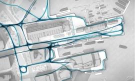
最后,更多的纹理被用在了行人交通线和船行交通线。行人交通线整合在一起是很困难的,但是我在Photoshop中画了一些线,又在网上找到一张航线的图片,把这二者局部结合起来完成了行人交通线的制作。
Finally, a few more textures were applied along with the pedestrian traffic and boat traffic line work. The pedestrian traffic lines were tricky to put together, but it ended up being a combination of painting the line work in Photoshop as well as dissecting parts of an image that I found online of flight paths.
我省略了这张分析图的许多细节。但是,当我为这个项目完成更多分析图时,我将会集中于使用过的具体技术。现在,我仍在实验和尝试方法。敬请期待!
I skimmed over many of the details of this illustration. However, as I generate more diagrams for this project, I will narrow in on specific techniques used. For now, I am still experimenting and testing out ideas. More on this later.
出处:本文译自visualizingarchitecture.com/,转载请注明出处。
|
|
专于设计,筑就未来
无论您身在何方;无论您作品规模大小;无论您是否已在设计等相关领域小有名气;无论您是否已成功求学、步入职业设计师队伍;只要你有想法、有创意、有能力,专筑网都愿为您提供一个展示自己的舞台
投稿邮箱:submit@iarch.cn 如何向专筑投稿?