Drone Applications for Landscape Architecture
由专筑网孙佳,小R编译
无人驾驶飞行器(UAV或无人机)有很多为景观设计服务的功能,早期能为一个已完成的项目进行现场分析,以达到为项目创造知名度和新颖性的目的。虽然半专业性的无人机现在很容易买到,并且价格便宜,但是要想创造优质的产品还是需要投入大量的时间。
景观设计师需要为他们的项目评估完成无人机直接操作的资源需求,或者考虑雇佣专业的无人机操作人员。然而无论是哪种方式,了解无人机的安全要求和相关规定都很重要。
业余爱好者的规则与商业上的规则不同,所以在实践中使用无人机之前理解这些差异至关重要。联邦航空局则要求做到(1)规则的学习;(2)通过远程飞行员考试(第107部分,无人机驾驶证书)和(3)向联邦航空局注册无人机。
Unmanned aerial vehicles (UAV’s or drones) have multiple applications for landscape architects, from early efforts like site analysis to creating awareness and excitement for a completed project. Although semi-professional drones are now readily available and inexpensive, there can be a heavy investment of time needed to create a quality product.
Landscape Architects will need to evaluate the resources necessary to perform drone operations directly or consider hiring professional drone pilots for their projects. Either way it’s important to understand safety requirements and regulations related to flying drones on a project site.
Rules for hobbyist differ from those operating commercially, and it’s critical to understand these differences before implementing drone use in your practice. Per FAA requirements this includes (1) Learning the Rules, (2) Pass the Remote Pilot Exam (Part 107, certified drone pilot) and (3) Registering your Drone with the FAA.

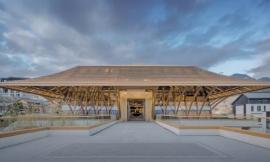
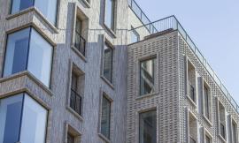
Image: Studio DPA
现场分析
线上航空测绘程序(如Google Earth)是一个很好的工具,能够帮助景观设计师和设计师们了解场地及其周围的环境。但是,这些程序存在一定的限制性,像是过时的图像和照片的质量,这些图像往往与现实存在着区别,并且缺乏细节。
无人机摄影可以大大提升照片的质量,并且还可以提供现状环境的资料。通过额外的服务和软件,景观设计师还可以为早期场地规划展示航拍地图。
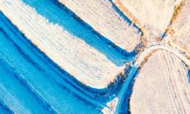
2017年,DPA工作室对亚利桑那州凤凰城一块25英亩的土地进行了视觉评估。该场地以前是一片柑橘农场和棕榈树苗圃,现场有许多的构筑物,包括复杂的平房、灌溉渠和农业设备。
开发者和项目组有兴趣记录这些现有的功能,用以更好的激发设计主题,包括重复使用现场发现的许多材料。一架无人机能够捕捉场地的空中镜头,然后与地面镜头相结合,制作成4分钟的汇总视频。
施工进度
在施工过程中,使用高分辨率的航拍可以为设计组提供场地的最新进展。景观设计师可以针对设计计划核实设计方案,或是在施工的早期阶段识别潜在的问题。
我们注意到总承包商和测量员越来越依赖无人机为场地提供的测量服务。景观设计师采用类似的测绘技术的潜力也很惊人。
虽然无人机不能取代现场审核的技术和经验,但是通过测绘完整的景观场地来核实工程量和场地布局的能力还是很有开发潜力,这可以有效地解决一项很费力的工作。
Site Analysis
Online aerial mapping programs (like Google Earth) are an excellent tool to help landscape architects and designers understand larger sites and their surrounding context. However, there are limits to these programs including outdated imagery and photo quality that is often inconsistent and lacking detail.
Drone photography can significantly increase image quality while also providing current documentation of existing conditions. With additional customization and software, the landscape architect can also prepare scalable aerial maps used for early site planning and exhibits.
In 2017, Studio DPA conducted a visual assessment of a 25-acre site in Phoenix, Arizona. The property was previously a citrus farm and palm tree nursery with a number of structures on the site including a ranch house complex, irrigation canals, and agricultural equipment.
The developer and project team were interested in documenting these existing features to help further inspire the design theme, including reuse of many materials found onsite. A drone was used to capture aerial footage of the property then combined with ground level shots to make a 4-minute video summarizing the results.
Construction Progress
Access to high resolution aerial imagery captured during construction can provide the design team the latest conditions on a site. The landscape architect can verify installation against the proposed design or identify potential conflicts early in construction.
We’ve noted general contractors and surveyors are increasingly relying on drones to provide mapping services for a property. The potential for landscape architects to employ similar mapping techniques is compelling.
Although UAV technology can’t replace the skill and experience of an in-person site review, the ability to map a completed landscape installation to verify quantities and layout is promising. This can be an efficient solution to an otherwise laborious task.

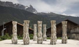
Image: Studio DPA
项目认知
也许无人机在景观领域最引人注目的功能是为项目带来新认知和刺激。这可以从项目的早期阶段开始,并在完成后持续进行。现在无人机可以测绘到整个场地的范围,这与之前费时费力的方法完全不同。高分辨率的图像通过网络的连接可以详细地显示开放空间、小径、集会空间等区域。
DPA工作室最近完成了一个项目视频,突出展示了亚利桑那州凤凰城Navarro Groves总体规划社区的景观改进。视频突出展示了入口纪念碑、庭院、绿化带、小径、集会区、火山坑和一些新植物。这是前面展示的同一项目,演示了无人机在项目生命周期中的各种用途。
Project Awareness
Perhaps the most compelling use of drones in landscape architecture is bringing awareness and excitement to a project, as well as the profession. This can begin in the early stages of a project and continue well after completion. The full scope of site improvements can now be captured in a manner that was difficult or costly prior to drones. High resolution imagery can show in detail a connected network of open space, trails, gathering spaces and other site improvements.
Studio DPA recently completed a project video highlighting the landscape architectural improvements at the Navarro Groves master planned community in Phoenix, AZ. The video features the entry monument, ramadas, green belts, trails, gathering areas, a fire pit, and new planting. This is the same project highlighted earlier and demonstrates the full range of drone use in the life cycle of a project.

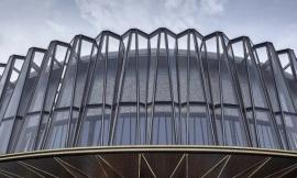
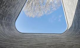
Image: Studio DPA
无人机图像有能按比例和环境测绘的能力,这对土地项目开发有更深远的影响。无人机的鸟瞰效果似乎很适合用于“分析、规划、设计、管理、建造建筑和自然环境”等职业。所有这些都可以帮助设计团队和利益相关者更直观地了解景观设计师的贡献。
建议和资源
- 审查并了解联邦航空局对商用无人机操作的要求;
- 您需要联邦航空局规定的第107部分的许可才能使用商业无人机;
- 请考虑人身伤害和财产损失的责任保险;
- 先学习无人机飞行技术,然后再专注于航拍技巧。YouTube是关于这两方面教程的最大资源;
- 我们使用大疆精灵和Mavic无人机,但市场上还是有许多制造商同样值得考虑;
- 图像和测绘是无人机的最大用途,但视频可以提供更加动态的观看体验,可以通过Adobe Premiere Pro,After Effects或Final Cut Pro等软件来学习视频编辑技能;
- 查看YouTube页面,了解更多无人机在专业上的使用方法。
UAV imagery has the ability to capture in scale and context the meaningful impacts we have on land development projects. The drones birds-eye perspective seems like a natural fit for a profession that seeks to “analyze, plan, design, manage, and nurture the built and natural environments”. All of which can help the design team and stake holders visualize a more holistic view of our contributions as landscape architects.
Recommendations and Resources
- Review and understand FAA requirements for commercial drone operations.
- You need a Part 107 license from the FAA to fly a drone commercially.
- To protect your landscape architecture practice, consider liability insurance covering bodily injury and property damage.
- Learn the mechanics of flying your drone first, then focus on your aerial photography skills. YouTube is a great resource for tutorials on both topics.
- We utilize DJI Phantom and Mavic drones, but there are a number of manufacturers in the market worth considering.
- Photography and mapping are great uses for a drone but video can provide a more dynamic viewing experience. Learn video editing skills with programs like Adobe Premiere Pro, After Effects, or Final Cut Pro.
- Check out our YouTube Page for more examples of how drones can be used in the profession.

Image: Studio DPA
|
|