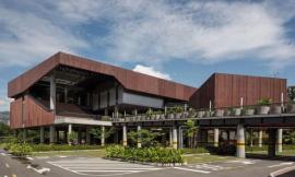
via Wikimedia. ImageDom Luis Bridge / Porto, Portugal
理解差异:将GIS和BIM之间的数据差异最小化
Mind the Gap: Minimizing Data Loss Between GIS and BIM
由专筑网李韧,邢子编译
在建筑、工程、施工行业都存在这样一个现象,项目规划、方案设计、实际施工、项目运营等关键阶段的重要数据常常不易被保留下来。
因为当项目的各个阶段进行数据交换的时候,不同的软件系统会造成数据之间的差异,因为这些软件只能识别自带的数据库。而当这些数据经过不同软件进行编译,其真实性和多样性就会降低。如果投资方需要了解项目早期的一些数据时,那么规划师、建筑师、工程师就必须手动创建这些信息,这会增加许多繁琐的工作。
但是,地理信息科学GIS行业正在逐步走向全面发展,并且结合建筑信息模型BIM的普及,这场变革将会清晰地反映设计和施工之间的转变,这也标志着GIS和BIM的集成使用即将到来。
BIM/GIS的结合
GIS信息主要用于在一定的背景环境中规划道路、桥梁、机场、铁路等基础设施项目中,而BIM信息模型则主要用于这些建筑的设计与施工。
将这二者结合,你就能够将地理空间信息结合到BIM模型之中。也就是说,GIS能够表明洪涝灾害多发地区,然后为设计者提供准确的信息,其中包括这些地质状况对建筑的场地、功能、材料的影响。
An unfortunate fact of the AEC (architecture, engineering, and construction) industry is that, between every stage of the process—from planning and design to construction and operations—critical data is lost.
The reality is, when you move data between phases of, say, the usable lifecycle of a bridge, you end up shuttling that data back and forth between software systems that recognize only their own data sets. The minute you translate that data, you reduce its richness and value. When a project stakeholder needs data from an earlier phase of the process, planners, designers, and engineers often have to manually re-create that information, resulting in unnecessary rework.
The good news is that a disruption is brewing in the GIS (geographic information science) industry as it rapidly moves toward 3D modeling. This evolution mirrors the transformation that the design and construction industry is experiencing as it moves from 2D to 3D BIM (Building Information Modeling), and it signals the emergence of GIS and BIM integration into one holistic environment.
The BIM/GIS Alliance Begins
While GIS information is necessary for planning and operating roads, bridges, airports, rail networks, and other infrastructure in the context of their surroundings, BIM information is key for the design and construction of those structures.
Put the two together, and you have a layer of geospatial context blended into the BIM model. What this means, for example, is that GIS can provide insight about flood-prone areas and give designers accurate information to influence a structure’s location, orientation, and even construction materials.

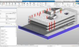
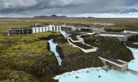
Courtesy of Autodesk
就尺度而言,GIS信息主要针对城市、行政区、国家尺度,而BIM数据则主要针对特定的建筑。通过BIM模型,你能够在同一个层面上设计实体模型,其中包括门窗、墙体等等。但是如果结合GIS,你就能够在一个更加广义的层面进行建筑设计,例如将建筑放置在某片特定场地或者道路之中。
当你将这两个尺度相结合时,便可以清除其中的多余数据。在BIM模型中添加地理背景往往意味着投资方能够得到更加恰当的设计方案,同时节约成本。
而这些信息都存储在云端,基础设施和建筑项目的投资方在任何地方都能够查看相关数据,因此省去了信息传输的麻烦,同时还可以在不同的背景项目中运用原有数据。
BIM + 地点数据 = 更好的设计方案和成本的节约
无论总承包商是否通过预制构件进行项目施工,当前都存在着提升运输效率和节约时间成本的问题。在全新的工业化施工过程中引入特定的空间维度,这也许能够大大提升在建项目的效率。
Esri和Autodesk公司努力研究BIM和GIS之间的软件互通性,这会在物理结构层面形成数字双生效应,然后在真实的世界中更好地完成方案设计,让项目的施工与运营更加高效。
同时,这些技术已经在整合中。例如,世界工程设计公司Mott MacDonald当前正将GIS和BIM结合在一起,用于完成纽约Catskill Aqueduct的修建项目。这一系列的数字化工作会以先进的方式记录、索引、检索信息,最终让项目能够成功投入使用。
And then there’s scale: GIS information operates at city, regional, and country scales, whereas BIM data applies to designing and building a specific shape or structure. Now, in BIM, you may design a physical structure at an object level—sketching a door, a window, or a wall. By adding GIS, you’re managing that structure in the context of a larger, smarter landscape. A building will be connected to a parcel of land, utilities, and roads.
When you bring together these two relative scales and move information seamlessly between them, you eliminate data redundancy. Adding better geospatial context to the BIM process means the project owner gets better designs and saves money.
With all information stored in the cloud, stakeholders in both infrastructure and building projects will be able to manage data in any environment in any part of the world, yet reuse and repurpose that information in other contexts without having to continuously convert data.
BIM + Location Data = Better Design and Long-Term Savings
Whether general contractors bring the construction process into a factory for prefabrication or turn the building site into an open-air factory, there’s a new focus on improving logistics scheduling and minimizing job time and waste. Bringing a spatial dimension into this new industrialized-construction process will increase the efficiency of every project being built.
Esri and Autodesk are working on improved software interoperability for BIM and GIS, which will create a “digital twin” of a physical structure to enable better design in the context of the real world, making both construction and operations more efficient.
In the meantime, synthesis of the technologies is already underway. Case in point: Global engineering and design and firm Mott MacDonald is integrating GIS and BIM to support the rehabilitation of the lower Catskill Aqueduct on a project in New York. The resulting digital work product provides a progressive way for information to be recorded, indexed, and easily retrieved to support the successful delivery of the project.

via Flickr user alh1
风险评估中的场地科学
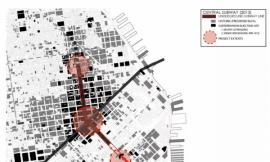
就当前而言,新道路、桥梁、基础设施的最大限度价值提升意味着以更加优化的方式来解决当今城市所面对的诸如可持续发展以及城市弹性等问题。因此这就需要灵活运用BIM、CAD、以及GIS之间的动态数据。
在实际场地中结合实际地理环境通过数字方式构思方案,这能够提前解决建筑与设计过程中所出现的诸多问题。在许多大型基础设施项目中,长时间的延误往往来源于规划和许可阶段,因为其中涉及到太多的社会、经济、环境影响等因素的风险评估。工程师和规划者能够利用地理数据在设计之前就解决这些问题,这便是他们如此看重洪水泛滥地区的信息或者地下设施的定位图像的原因。因此,在方案中结合使用GIS和BIM,何乐而不为呢?
当项目已建成,GIS和BIM数据同样有用,相较于其他设施管理中的最终数据而言,GIS和BIM模型的结合能够灵活表达各种数据需求。投资方也能够在项目的全生命周期内查看这些重要数据。
举例来说,一条道路投入使用便意味着设施的管理,那么就需要安装护栏、分隔带、设置监管人员。但其中仍然存在多次翻修和改造的契机,那么,当GIS、CAD、BIM结合使用时,你便能够提升项目的可行性,同时减少错误,而这种技术在项目的后期维护中同样发挥着重要作用。
The Science of “Where” in Risk Assessment
Maximizing the long-term value of new roads, bridges, and facilities means delivering better designs to solve many of the sustainability and resiliency issues facing cities today. This will require optimizing dynamic data interchange between BIM, CAD (computer-aided design), and the geospatial information provided by GIS.
Placing a digital design in a real place, within real geography, eliminates much of the front-end risk of designing and building. The biggest delays in large infrastructure projects come from the planning and permitting phases, which involve a lot of assessments of social, economic, and environmental impacts. Engineers and planners do much of that assessment outside of the design process using geospatial data; that’s how they look at floodplain maps or locate underground utilities. So, why not design using GIS and BIM data simultaneously?
This GIS and BIM integration is equally useful once a structure is built. Rather than oversimplifying the end data provided for facilities management, the flexible model—connected to GIS—delivers everything operations need. Customers have the ability to reuse that data throughout the structure’s lifecycle.
For example, operating a road in the real world means managing utilities, managing guardrail installation, maintaining striping, and overseeing maintenance crews. There’s a lot of retrofitting and renovation. When GIS, CAD, and BIM are connected, you’re improving operability and eliminating errors. This technology convergence will play an important role in predictive maintenance, too.

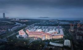
Courtesy of Autodesk
关闭数据循环
为了建造智能城市,人们需要作出更加明确的规划设计,这也是GIS和BIM如此重要的原因,它们能够促进自动驾驶汽车的发展,因为汽车传感器需要不断地收集实时讯息。但是,由于导航、地理定位、路线创建的需求,这些软件则依赖于高精度的电子地图。
电子地图可以通过计算机进行编辑,其中包含有世界地理空间信息的3D道路系统。在未来,当自动驾驶汽车收集到诸如道路施工或封闭等实时更新的地理信息,电脑便也能够自动识别哪些地区存在安全隐患,然后将这些信息反馈给相关人员进行道路的后期维护。这个过程实时而迅速,在未来的道路发展中会使用得更加普遍。
实时传感系统、地理数据、模型数据的相关性提升了设计师的观察力,同时也促进了基础设施规划设计的稳步发展。
Closing the Data Loop
To create smarter cities, we need to make smarter planning decisions, which is why connecting BIM and GIS is so critical. Think of what integrating these systems can do for the evolution of autonomous vehicles: Car sensors are constantly collecting real-time information. However, they rely upon a highly accurate machine map for navigation, local geometry, and the creation of their electronic horizon.
The machine map, which can be interpreted by computers, is best described as a 3D highway-design file enriched with real-world geospatial information. As the autonomous vehicles of tomorrow collect updated road geometry information such as lane closures or changes due to construction, they will identify high-risk areas, which can be fed back to planners designing and maintaining future roads. The whole process will become more seamless, and the Department of Transportation will become more responsive when fixing deteriorating roads.
Connecting real-time sensor systems, geographic data, and modeling data improves everyone’s insight, leading to better infrastructure-design decisions at any scale.
|
|